
In 1826, a German landowner named Johann Heinrich von Thünen wondered why the farms around his estate near Rostock grew different things at different distances from town. His answer became one of geography's oldest models, and it still helps explain the dairy farms near big cities and the cattle ranches far from them.
The model
The von Thünen model explains rural land use by the cost of transport to a single market. Farmers choose the use that earns them the most profit at their distance from the market, after paying to haul their product there. This is the same reasoning as bid-rent theory: the use that can pay the most for land at each distance wins it.
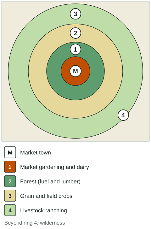
- Ring 1: market gardening and dairy. Vegetables and milk spoil fast and are heavy, so they are produced closest to the market.
- Ring 2: forest. In the 1820s, towns needed wood every day for fuel and building. Wood is heavy and bulky, so hauling it far by cart cost too much.
- Ring 3: grain and field crops. Grain keeps well and is lighter for its value, so it can travel farther.
- Ring 4: livestock ranching. Animals can walk to market, and grazing needs much cheap land.
Beyond ring 4 lies wilderness, where no product can pay its transport cost. Notice that intensity falls with distance: the inner rings are farmed intensively and the outer rings extensively.
Assumptions
Like every model, von Thünen's simplifies the world so one factor can be studied. He imagined an "isolated state" with:
- one market town and no trade with the outside;
- a flat plain with the same soil and climate everywhere;
- transport by horse and cart, equally easy in every direction;
- farmers who sell to the market and want the most profit.
Von Thünen also showed what happens when one assumption changes. A navigable river makes transport cheaper along its banks, so the rings stretch out along it into long ovals.
Limits: where the rings break
Real regions break the assumptions, so real land use rarely forms neat rings.
| What changed | Effect on the rings | Example |
|---|---|---|
| Refrigeration and fast transport | Perishable goods can travel far | Lamb shipped from New Zealand to the United Kingdom; cut flowers flown from Kenya to Europe |
| Specialty farming regions | Places specialize by climate, not distance | Grapes and wine in the Napa Valley, California; out-of-season fruit from Chile for US stores |
| Many markets | Rings form around each town and overlap | Western Europe, with many large cities close together |
| Uneven land | Soil, slope and water shape land use | Irrigated valleys and dry hills side by side in central Chile |
| Wood replaced by coal, oil and gas | Forest is no longer needed near towns | Most modern cities |
The model still works in parts. Dairy farms in many countries cluster near large cities, and extensive ranching still takes the cheapest, most distant land. Some geographers even apply the rings at the global scale, with Western Europe or the northeastern United States as the market and ranching on far continents such as South America and Australia. The value of the model is the logic it teaches: distance and transport cost help decide what farmers grow.
Using the model on the exam
When you apply von Thünen to a map, name the ring a land use falls in, explain it with transport cost and perishability, and then say where the real pattern departs from the model and why. A strong answer about a limit names the assumption that fails and a real place where it fails: "The model assumes transport by cart, but refrigerated shipping lets New Zealand sell lamb in the United Kingdom."