
Not every boundary is between countries. Inside a state, internal boundaries divide the land into provinces, counties, cities and the voting districts that elect representatives. Where those lines fall can decide who wins an election.
Voting districts
In many countries, including the United States, the United Kingdom and India, voters are grouped into districts, and each district elects one representative. For that to be fair, each district should hold about the same number of people. The United States House of Representatives has 435 seats. After each census, every 10 years, two steps follow:
- Reapportionment: the 435 seats are shared out among the 50 states by population. After the 2020 census, Texas gained two seats, and states such as Ohio and New York lost one each.
- Redistricting: each state redraws its district lines so its districts are about equal in population.
Redistricting happens at several scales: US House districts inside each state, districts for each state's own legislature, and, at the local scale, districts for city councils and school boards.
Gerrymandering: packing and cracking
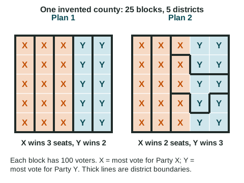
Gerrymandering is drawing district lines to give one party or group an advantage. The word comes from 1812, when Massachusetts governor Elbridge Gerry signed a map with a district shaped, one newspaper said, like a salamander. Line drawers use two methods:
- Packing crowds as many of the other party's voters as possible into a few districts. That party wins those districts by huge margins, so many of its votes are wasted: they add nothing once the seat is won.
- Cracking splits the other party's voters across many districts, so they are outvoted in each and elect no one.
Look at the drawing. The county has 25 blocks of 100 voters each; 15 blocks lean to Party X and 10 to Party Y. Plan 1 uses five straight columns, and X wins 3 seats to Y's 2, close to the vote. Plan 2 packs X into the two left columns and cracks the remaining X blocks across three bent districts. Now Y, with about 40% of the voters, wins 3 of 5 seats (60%). The voters did not change; the lines did.
On the exam, naming packing or cracking earns little. The readers who score it report that students lose the point when they do not say what the method does to the votes. Say it: packing wastes votes in lopsided wins; cracking spreads votes too thin to win; either way, a party can win fewer seats than its share of the votes.
Limits on gerrymandering
| Rule or practice | What it does | Example |
|---|---|---|
| Independent commission | People who are not running for office draw the lines | Arizona and Michigan (US states); the boundary commissions of the United Kingdom |
| Compact districts that keep places whole | Makes long, twisting shapes harder to draw | Rules in many US state constitutions |
| Equal population | Each district holds about the same number of people | Required for US House districts |
| Protecting minority voters | Districts may be drawn so a minority group can elect a candidate it chooses | The Voting Rights Act of 1965; in 2026 the US Supreme Court narrowed when the act requires such districts (Louisiana v. Callais) |
In 2019, the US Supreme Court ruled that federal courts cannot decide claims that a map unfairly favors a party (Rucho v. Common Cause), so state courts, state laws and commissions are now the main checks. Commissions can also be set aside: in 2025, Texas redrew its US House map in the middle of the decade, and California voters then chose a map drawn by their legislature, in place of their commission's map, for the 2026 to 2030 elections. Gerrymandering is argued over by both major parties, and each has drawn maps that favor itself. A shape is a clue, not proof: compact districts can still be drawn to favor one side, and some odd shapes simply follow rivers or county lines.
Why it matters for geography
Gerrymandering is a clear case of boundaries shaping power. A line on a map, drawn inside one state, can decide which party controls a legislature and which laws pass, at the local, state and national scales.