
A boundary (or border) is an invisible line, on land or at sea, that marks where the territory of one state ends and another begins. You usually cannot see it on the ground, but it decides which laws apply, which government collects taxes and who may cross without a passport. Boundaries also divide smaller units, such as US states or Canadian provinces. This topic sorts boundaries into types by their history.
Three questions that sort every boundary
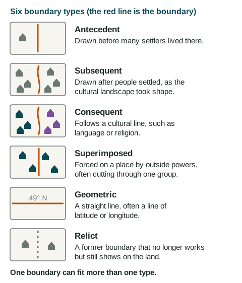
To name a boundary's type, ask three questions. When was it drawn: before or after people settled the area? What does it follow: a cultural line, a straight line, or nothing anymore? Who drew it: the people who live there, or an outside power?
Timing: antecedent and subsequent
An antecedent boundary is drawn before many settlers live in an area. Settlement then grows up on each side of it. In the west of North America, the United States and Britain agreed in 1818 and 1846 on a line along 49° N, before most settlers arrived. Indigenous peoples already lived there, so "before settlement" really means before large-scale settlement by newcomers. The Chile and Argentina boundary, agreed in 1881 along the high peaks of the Andes, is often called antecedent too.
A subsequent boundary is drawn after an area was settled, as the cultural landscape took shape. The boundary between China and Viet Nam grew out of centuries of settlement and conflict before it was fixed by treaty.
What it follows: consequent and geometric
A consequent boundary, also called an ethnographic boundary, follows a cultural line such as language or religion. When British India became independent in 1947, a British official drew the line between India and Pakistan to separate areas with mostly Muslim and mostly Hindu populations. About 15 million people (estimates range from about 10 to 20 million) moved across the new line in the following months, and many were killed in violence.
A geometric boundary is a straight line, often along a line of latitude or longitude. For about 2,000 kilometers, the US and Canada line runs along 49° N. Straight lines also divide units at the subnational scale: Colorado and Wyoming are separated by a line along 41° N.
Who drew it: superimposed, and what remains: relict
A superimposed boundary is forced on an area by an outside power, often without regard for the peoples who live there. At a meeting in 1884 and 1885, European powers set rules for claiming Africa, and over the next decades they drew many borders across it. The Maasai, for example, were split between British East Africa (now Kenya) and German East Africa (now mainland Tanzania). Korea was divided in 1945 by the United States and the Soviet Union, two outside powers.
A relict boundary no longer works as a border but can still be seen in the cultural landscape. Germany was divided into East and West from 1949 to 1990; a long strip of land along the old line is now protected, and watchtowers still stand. In Berlin, pieces of the Berlin Wall (1961 to 1989) remain as a memorial. Hadrian's Wall, built by the Romans across northern England, is a much older relict boundary.
One boundary, several types
The types answer different questions, so one boundary can fit several. The readers who score the exam accept any type that fits, if you explain it.
| Boundary | Types it fits | Why |
|---|---|---|
| United States and Canada (west) | Geometric, antecedent | Straight along 49° N; agreed before most settlers arrived |
| India and Pakistan | Consequent, superimposed | Follows religious majorities; drawn by a British official in 1947 |
| Kenya and Tanzania | Geometric, superimposed | Straight sections drawn by Britain and Germany through Maasai lands |
| Former East and West Germany | Relict (and superimposed when drawn) | Set by the powers that occupied Germany after 1945; gone since 1990 |
Do not confuse boundary types with region types. Formal, functional and perceptual regions are ways of grouping places; antecedent, subsequent and the rest are ways of describing the lines between states.