
The political map has not always looked the way it does. In 1945, the United Nations began with 51 member states; by 2011 it had 193 (UN, 2026). Most of the new states were once colonies. This topic explains the political processes that drew the map: colonialism, the ideas of sovereignty and self-determination, independence movements, and the breakup of large states.
Sovereignty and self-determination
Sovereignty is a state's right and power to govern its own territory and people without control from outside. A sovereign state makes its own laws, controls its borders and decides who may enter. When soldiers from one state cross into another without permission, they break that state's sovereignty.
Self-determination is the right of a people, a nation, to choose its own political status. A nation may use it to seek a state of its own, or more powers inside an existing state. In 1960, the UN General Assembly declared that "all peoples have the right to self-determination" (Resolution 1514). The two ideas are linked but not the same: self-determination belongs to peoples, sovereignty to states.
| Sovereignty | Self-determination | |
|---|---|---|
| Who holds it | A state | A people (a nation) |
| What it is | Control over a territory, free from outside rule | The right to choose a political future |
| Example | Kenya decides who may cross its borders | People in East Timor voted in 1999 to leave Indonesian rule |
Colonialism and imperialism drew many borders
From the 1500s to the 1900s, European states built empires. Imperialism is one state extending its power over other peoples and lands; colonialism is the direct control, and often settlement, of those lands. Spain and Portugal ruled most of Latin America. By 1914, European powers controlled almost all of Africa, and Britain ruled India. Colonial rulers drew borders to suit their own goals: to split land between empires, or to follow rivers and straight lines on a map. Those borders often split one people between two colonies or grouped rival peoples together. Nigeria, for example, was shaped by British officials in the early 1900s and holds the Hausa, Yoruba, Igbo and hundreds of other groups.
Independence movements
An independence movement is an organized effort by a people under outside rule to win a state of their own. Movements used many methods. In India, a mass movement led by figures such as Mohandas Gandhi used protests, boycotts and refusal to obey British laws, and India became independent in 1947. In Algeria, a war against French rule lasted from 1954 to 1962. Ghana won independence from Britain in 1957, one of the first states in Sub-Saharan Africa to do so.
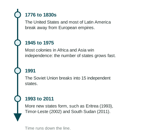
New states came in waves. At the global scale:
- 1776 to the 1830s: the United States and most of Latin America broke away from European empires.
- 1945 to 1975: after World War II, weakened European powers gave up most of their colonies in Africa and Asia. In 1960 alone, 17 African states became independent.
- 1991: the Soviet Union broke into 15 independent states, among them Russia, Ukraine, Kazakhstan and Estonia. Yugoslavia broke apart in the 1990s too.
- 1993 to 2011: a few more states formed, such as Eritrea (1993), Timor-Leste (2002) and South Sudan (2011).
The colonial map stayed
When colonies became states, most kept the borders they had. In 1964, the Organization of African Unity agreed that its members would respect the borders they held at independence, to avoid wars over redrawing them. This kept the peace between many states, but it also kept groups inside borders they had never chosen. Some later used self-determination against their own new state: people in southern Sudan fought for decades and voted for independence in 2011, creating South Sudan. So at the national scale, colonialism still shapes conflicts long after it ended.
Reading the political map
When you see a state on a map, ask three questions. Who drew its borders, and when? Did it win independence through a movement, a war or a vote? Do the peoples inside it see themselves as one nation? The answers explain much of what happens next in this unit.