
Geographic data are not just facts in a table. Governments, businesses and families use them to decide where money, buildings and help should go. This topic is about that power, and about the limits that come with it.
The census
A census is an official count of all the people in a country. Many countries take one every ten years, and some every five. Besides counting people, a census usually records facts about each household: ages, the number of people in a home, the language spoken, whether the home has piped water or electricity. Because every household is counted, the results can be mapped down to small areas such as districts or city blocks.
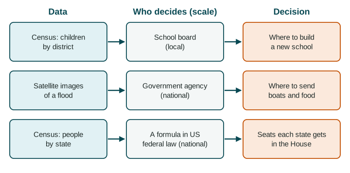
The United States has counted its people every ten years since 1790, most recently in 2020. Each new count decides how the 435 seats in the House of Representatives are shared among the states, a decision at the national scale. Census counts are also used to share federal money for roads, schools and hospitals.
Satellite images
Satellite images, a kind of remote sensing, show the ground from above. They can measure how far a city has spread, which fields are green and which streets are flooded. In February 2023, after earthquakes in southern Türkiye and northern Syria, UN satellite analysts compared images from before and after to map damaged buildings across many towns, starting within days. Maps like these help rescue and aid groups decide where to go first.
Who decides, at what scale
| Who decides | Example | Scale |
|---|---|---|
| An individual or family | A family in Houston checks an official flood map before buying a house. | Local |
| A business | A grocery chain studies census counts of households in Atlanta's neighborhoods to choose where to open a store. | Local |
| A local government | A school board uses census counts of children by district to choose where to build a school. | Local |
| A national government | The United States shares House seats among states by census counts. | National |
| International bodies | UN agencies use satellite images to target aid after a disaster that crosses borders. | Regional or global |
Data and decisions often join in a GIS. In a flooded town, staff can layer satellite images of flooded streets over census counts of people on each block, then pick shelters within walking distance of the most crowded blocks.
Limitations of data
Every source has a limitation of data: something it cannot show or may get wrong. Good geographers name the limits before trusting a number.
- Out of date. India's census due in 2021 was postponed (the next count was set for 2026 and 2027), so for years planners had to rely on counts from 2011, missing a decade of growth and movement.
- Undercounts. Some people are hard to count: people without a fixed home, people in remote villages, people who distrust the government. Places with many of them can lose funding or seats.
- What satellites cannot see. Clouds hide the ground from ordinary cameras, and no satellite can see who lives inside a building or why.
- One value for a big area. A single number for a whole city hides which neighborhoods lack pipes or clinics. The data must match the scale of the decision.