Latitude sets how much sunlight a place gets, but it does not settle the climate by itself. Two towns at the same latitude can be a rainforest and a desert, or have mild winters and frozen ones. The difference comes from geography: mountains, the ocean, the currents in it, and height above sea level. This page explains each one.
Mountains and the rain shadow
When prevailing winds push moist air from the ocean against a mountain range, the air has nowhere to go but up. As it rises up the windward side (the side facing the wind), it expands and cools. Cool air holds less water vapor, so the vapor condenses into clouds, and rain or snow falls on the windward slopes. Those slopes are often green and forested.
By the time the air crosses the peaks, it has lost most of its water. As it sinks down the leeward side (the side away from the wind), it is squeezed by the air above it and warms. Warm, dry air rarely forms clouds, so the leeward side is dry. This dry region is a rain shadow.
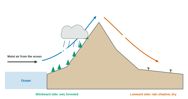
Examples: in the westerlies, the Cascades and the Sierra Nevada catch moist Pacific air, leaving deserts and dry grasslands to their east. The Himalayas block moist air from reaching much of central Asia, helping to make the Gobi Desert dry. Knowing the direction of the prevailing wind tells you which side is wet.
Land, water and mild coasts
Water takes far more energy to warm up than rock or soil, and it gives that energy back slowly. So in summer the ocean stays cooler than the land, and in winter it stays warmer. Air over the ocean takes on the ocean's temperature, and winds carry it over the coast.
The result: coastal places have smaller swings between summer and winter than inland places at the same latitude. San Francisco's warmest and coldest months differ by only about 7 °C; places deep inside a continent, far from any ocean, can have hot summers and bitter winters.
Worked example. An inland town averages −8 °C in its coldest month and 26 °C in its warmest. What is its yearly temperature range?
Warmest minus coldest:
Subtracting a negative number adds it. A coastal town at the same latitude might have a range of only 10 °C to 15 °C.
Ocean currents carry heat
Prevailing winds drag the ocean's surface water along. Earth's rotation turns the moving water (the Coriolis effect again), and the continents block it, so the surface water flows in huge loops called gyres. In the Northern Hemisphere the big gyres turn clockwise; in the Southern Hemisphere, counterclockwise.
| Warm current | Cold current | |
|---|---|---|
| Flows | from the tropics toward the poles | from high latitudes toward the equator |
| Usually along | the east coasts of continents | the west coasts of continents |
| Example | the Gulf Stream, along eastern North America and on toward Europe | the California Current, along western North America |
| Effect on the coast | warmer, often wetter | cooler, often foggy and dry |
The Gulf Stream and its extension carry tropical heat across the Atlantic. Westerly winds bring the mild ocean air over Britain and western Europe, which is why London has much milder winters than Calgary, Canada, at the same latitude. A cold current cools the air above it, which then holds little moisture, so some coasts along cold currents are deserts, such as the Atacama in Chile.
Ocean currents also move nutrients and the organisms that drift with them, which affects fisheries. The next topic shows what happens when the winds that drive the Pacific currents weaken or strengthen.
Elevation
Air cools about 6.5 °C for every kilometer you climb in the troposphere. So mountains are colder than the land around them, and high mountains near the equator, such as Kilimanjaro, can have glaciers above tropical savanna. Climbing a high mountain is a bit like traveling toward the poles: forests give way to shrubs, then tundra-like plants, then ice.
Putting it together
To explain a place's climate on the exam, check these in order: latitude (how much sunlight), the prevailing wind (where the air comes from), mountains (windward or leeward), the ocean (coastal or inland, and which current is offshore) and elevation.
Check yourself
- Which side of a mountain range is in the rain shadow? (The leeward side.)
- Why are coastal winters milder? (Water cools more slowly than land, and ocean air warms the coast.)
- What drives the ocean's surface currents? (Prevailing winds, turned by the Coriolis effect and the continents.)