Global Wind Patterns
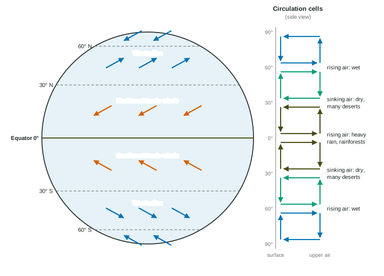
The Sun heats the equator most, so air rises there, drops its rain, travels poleward high up and sinks near 30°, forming the Hadley cell; Ferrel and polar cells lie beyond it.
Part 1 · Hook
Why this matters
Part 2 · Before you start
What this builds on
Part 3 · Prerequisite check
Quick check before you start
1. What drives convection?
- Warm, less dense material rising and cooler, denser material sinking
- The Moon pulling on Earth
- Plants releasing oxygen
- Salt dissolving in water
Show the answer
Uneven heating makes warm material rise and cool material sink, forming a loop.
- Correct: Warm, less dense material rising and cooler, denser material sinking:
- The Moon pulling on Earth:
- Plants releasing oxygen:
- Salt dissolving in water:
2. In which layer of the atmosphere does weather happen?
- Troposphere
- Stratosphere
- Mesosphere
- Thermosphere
Show the answer
The troposphere holds nearly all the water vapor and weather.
- Correct: Troposphere:
- Stratosphere:
- Mesosphere:
- Thermosphere:
3. Which biome has high temperatures and very high rainfall all year?
- Tropical rainforest
- Desert
- Tundra
- Taiga
Show the answer
Tropical rainforests are hot and wet year-round.
- Correct: Tropical rainforest:
- Desert:
- Tundra:
- Taiga:
Part 4 · See it
See it first
Part 5 · Step by step
How it works, step by step
- The Sun heats the equator more than the poleswarm air rises at the equator, cools and drops heavy rain
- The dry air spreads toward the poles high up, then sinks near 30°sinking air warms, so the 30° latitudes are dry and hold many deserts
- Air flows back toward the equator along the surface, completing the Hadley cellsteady surface winds form between the equator and 30°
- Earth's rotation deflects moving air (the Coriolis effect)winds curve into the trade winds, the westerlies and the polar easterlies
Part 6 · Key ideas
Key ideas
- Uneven heating makes air rise near the equator and near 60° (wet) and sink near 30° and the poles (dry). The loops are circulation cells: the Hadley cell (0-30°), the Ferrel cell (30-60°) and the polar cell (60-90°).
- The Coriolis effect: Earth's rotation deflects moving air to the right in the Northern Hemisphere and to the left in the Southern Hemisphere.
- Surface winds: the trade winds (0-30°) blow from the east toward the equator; the westerlies (30-60°) blow from the west; the polar easterlies (60-90°) blow from the east.
- Winds are named for where they come from: a westerly blows from the west toward the east.
- Global winds move heat from the tropics toward the poles and set where rain falls, so they help place biomes: rainforests near the equator, deserts near 30°.
Part 7 · Misconception
A common mistake
The wrong idea: The westerlies blow toward the west.
What actually happens: Winds are named for the direction they come from. The westerlies come from the west and blow toward the east, which is why weather in the United States usually moves from west to east.
Part 8 · Check yourself
Check yourself
Exam-style questions. Anything you miss goes into your review queue.
1. Why do the trade winds in the Northern Hemisphere blow from the northeast instead of straight from the north?
- Earth's rotation turns moving air to the right
- The rising Sun in the east pushes the air west
- Mountains along the equator turn the wind to the west
- Warm air at the equator pulls the wind toward it from the east
Show the answer
Air flowing toward the equator is deflected by Earth's rotation, the Coriolis effect: to the right in the Northern Hemisphere, so a north wind becomes a northeast wind.
- Correct: Earth's rotation turns moving air to the right: Right: the Coriolis effect turns the wind to the right in the Northern Hemisphere.
- The rising Sun in the east pushes the air west: Sunlight heats air; it does not push it west.
- Mountains along the equator turn the wind to the west: There is no continuous mountain range along the equator.
- Warm air at the equator pulls the wind toward it from the east: Air at the equator rises; it draws air in from the north and south, and the turn comes from rotation.
2. Many of the world's large deserts, such as the Sahara, lie near 30° N or 30° S. Why?
- Dry air sinks there and warms, so clouds rarely form
- The trade winds blow sand from the equator to 30°
- Those latitudes receive the most direct sunlight
- Rising air there cools and drops its rain out at sea
Show the answer
Air that rose at the equator dropped its rain there. It sinks near 30°, warming as it falls, so it can hold more water and clouds rarely form.
- Correct: Dry air sinks there and warms, so clouds rarely form: Right: sinking, warming air makes the 30° latitudes dry.
- The trade winds blow sand from the equator to 30°: Trade winds carry air, not most of the sand in the Sahara.
- Those latitudes receive the most direct sunlight: The most direct sunlight falls near the equator.
- Rising air there cools and drops its rain out at sea: Air sinks at 30°; it rises near the equator and near 60°.
Model or diagram
Surface winds and circulation cells
3. In the diagram, which winds blow at the surface between about 30° N and 60° N?
- The westerlies
- The northeast trade winds
- The polar easterlies
- The southeast trade winds
Show the answer
Between 30° and 60° the surface winds blow from the west toward the east: the westerlies. They carry weather across most of the United States from west to east.
- Correct: The westerlies: Right: the westerlies blow between 30° and 60°.
- The northeast trade winds: The trade winds blow between the equator and 30°.
- The polar easterlies: The polar easterlies blow poleward of 60°.
- The southeast trade winds: The southeast trade winds are in the Southern Hemisphere, between the equator and 30° S.
4. The diagram shows air rising at both the equator and 60°, and sinking at 30° and the poles. Which statement explains the pattern of wet and dry places it labels?
- Rising air cools and makes rain; sinking air warms and dries
- Sinking air cools and makes rain; rising air warms and dries
- Places with rising air get less sunlight, so they stay wet
- Sinking air carries water down from the upper air as rain
Show the answer
Rising air expands and cools, so its water vapor condenses into clouds and rain. Sinking air is compressed and warms, so clouds evaporate.
- Correct: Rising air cools and makes rain; sinking air warms and dries: Right: rising means rain, sinking means dry.
- Sinking air cools and makes rain; rising air warms and dries: The pattern is reversed: rising air cools, sinking air warms.
- Places with rising air get less sunlight, so they stay wet: The equator gets the most sunlight and is very wet.
- Sinking air carries water down from the upper air as rain: Air high up is dry; sinking air brings no rain.
5. A sailing ship leaves Spain (about 40° N) and heads for the Caribbean (about 15° N). According to the diagram, which winds should it use for the long crossing west?
- The northeast trade winds, after sailing south to below 30° N
- The westerlies, staying at 40° N the whole way
- The polar easterlies, after sailing north of 60° N
- The southeast trade winds, after crossing the equator
Show the answer
The trade winds blow from the east, toward the west, between about 30° N and the equator. Sailing ships went south first to catch them, then rode them west.
- Correct: The northeast trade winds, after sailing south to below 30° N: Right: the northeast trades push ships west below 30° N.
- The westerlies, staying at 40° N the whole way: The westerlies blow toward the east, against a ship sailing west.
- The polar easterlies, after sailing north of 60° N: Going north of 60° is far out of the way, and the Caribbean is in the tropics.
- The southeast trade winds, after crossing the equator: The Caribbean is north of the equator, so crossing it is not needed.
6. Smoke from large fires in the western United States, near 40° N, often drifts over the eastern states days later. Which feature in the diagram explains this?
- The westerlies carry air east at these latitudes
- The trade winds carry air from west to east at these latitudes
- The Hadley cell lifts the smoke high over the equator
- The polar easterlies push the smoke south and east
Show the answer
Between about 30° and 60° N the prevailing winds are the westerlies, so smoke, dust and storms usually move from west to east across North America.
- Correct: The westerlies carry air east at these latitudes: Right: the westerlies move air eastward across the middle latitudes.
- The trade winds carry air from west to east at these latitudes: The trade winds blow from east to west, and only between the equator and 30°.
- The Hadley cell lifts the smoke high over the equator: The Hadley cell lies between the equator and 30°.
- The polar easterlies push the smoke south and east: The polar easterlies blow north of 60°.
Part 9 · Summary
Summary
Part 10 · Up next
What comes next
Part 11 · Connections