El Niño and La Niña
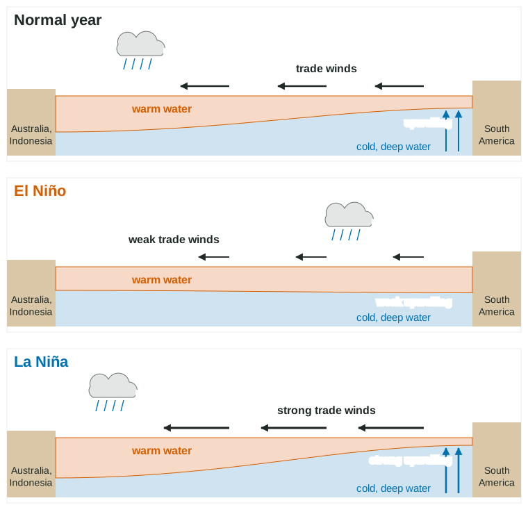
Normally the trade winds push warm water west across the Pacific, and cold, nutrient-rich water upwells off South America.
Part 1 · Hook
Why this matters
Part 2 · Before you start
What this builds on
Part 3 · Prerequisite check
Quick check before you start
1. Which way do the trade winds blow over the equatorial Pacific?
- From east to west, toward Asia and Australia
- From west to east, toward South America
- From the equator toward the poles
- Straight up from the ocean
Show the answer
The trade winds blow from the east toward the west (and toward the equator).
- Correct: From east to west, toward Asia and Australia:
- From west to east, toward South America:
- From the equator toward the poles:
- Straight up from the ocean:
2. What mainly drives surface ocean currents?
- Prevailing winds
- The tides
- Rivers
- Underwater volcanoes
Show the answer
Winds drag the surface water; Earth's rotation and the continents turn it into gyres.
- Correct: Prevailing winds:
- The tides:
- Rivers:
- Underwater volcanoes:
3. Why do fish populations depend on nutrients in the water?
- Nutrients feed the phytoplankton at the base of the food web
- Fish absorb nutrients directly through their skin for energy
- Nutrients warm the water for fish
- Nutrients make the water saltier
Show the answer
Phytoplankton need nutrients such as nitrate and phosphate; everything else eats them or eats something that does.
- Correct: Nutrients feed the phytoplankton at the base of the food web:
- Fish absorb nutrients directly through their skin for energy:
- Nutrients warm the water for fish:
- Nutrients make the water saltier:
Part 4 · See it
See it first
Part 5 · Step by step
How it works, step by step
- In a normal year the trade winds push warm surface water westwarm water piles up near Indonesia, and cold, nutrient-rich water upwells off Peru
- In an El Niño the trade winds weakenwarm water spreads east, upwelling off South America weakens and the eastern Pacific warms
- Fewer nutrients rise off Peruphytoplankton decline, so anchovies, seabirds and the fishing industry suffer
- The warm water, and the rising, rainy air above it, shift eastPeru and Ecuador flood while Indonesia and Australia face drought and wildfire
- In a La Niña the trade winds strengthenupwelling increases, the eastern Pacific cools and the rain stays farther west than normal
Part 6 · Key ideas
Key ideas
- Upwelling: when wind pushes surface water away from a coast, cold, nutrient-rich water rises from below. It makes coasts like Peru's some of the richest fisheries on Earth.
- El Niño: weak trade winds, warm water spreads east, weak upwelling off South America; rain shifts east (floods in Peru, the southern United States wetter in winter), drought in Indonesia and Australia.
- La Niña: strong trade winds, strong upwelling, a cooler-than-average eastern Pacific; the reverse effects (drought in Peru and the southern United States, heavy rain in Indonesia and Australia).
- Together they are the El Niño-Southern Oscillation (ENSO), a natural cycle that swings every 2 to 7 years; each phase usually lasts about 9 to 12 months.
- ENSO affects the whole world: El Niño years tend to be warmer globally and have fewer Atlantic hurricanes; La Niña years tend to have more.
Part 7 · Misconception
A common mistake
The wrong idea: El Niño and La Niña are the same thing, or La Niña is just a weaker El Niño.
What actually happens: They are opposites. El Niño: weak trade winds, warm eastern Pacific, weak upwelling. La Niña: strong trade winds, cold eastern Pacific, strong upwelling. Remember: El Niño warms the water off Peru.
Part 8 · Check yourself
Check yourself
Exam-style questions. Anything you miss goes into your review queue.
1. During an El Niño, what happens to the trade winds over the equatorial Pacific?
- They weaken
- They strengthen
- They reverse and blow toward the poles
- They stay exactly as in a normal year
Show the answer
In an El Niño the trade winds weaken (or even reverse in places), so they stop holding warm water in the western Pacific.
- Correct: They weaken: Right: weaker trade winds mark an El Niño.
- They strengthen: Stronger trade winds are a La Niña.
- They reverse and blow toward the poles: The trade winds blow toward the west and the equator; they do not turn toward the poles.
- They stay exactly as in a normal year: The change in the trade winds is what defines the event.
2. Why does the fish catch off Peru often drop during an El Niño?
- Weaker upwelling brings up fewer nutrients
- The water turns too cold for the anchovies to survive
- Stronger trade winds make the sea too rough for boats
- Heavy rain makes the coastal ocean too fresh for the fish
Show the answer
Weak upwelling brings fewer nutrients up. With less phytoplankton at the base of the food web, the anchovies and the animals that eat them decline.
- Correct: Weaker upwelling brings up fewer nutrients: Right: less upwelling means fewer nutrients, less plankton and less food.
- The water turns too cold for the anchovies to survive: El Niño makes the water off Peru warmer, not colder.
- Stronger trade winds make the sea too rough for boats: Trade winds weaken during El Niño.
- Heavy rain makes the coastal ocean too fresh for the fish: Coastal rain does not make the open ocean fresh enough to kill fish.
3. During a La Niña, which conditions are most likely in Indonesia and in coastal Peru?
- Heavy rain in Indonesia; dry in Peru
- Drought in Indonesia; heavy rain in Peru
- Drought in both Indonesia and Peru
- Heavy rain in both Indonesia and Peru
Show the answer
In La Niña the strong trade winds pile warm water and rising, rainy air even farther west, over Indonesia, while the cold eastern Pacific keeps Peru dry.
- Correct: Heavy rain in Indonesia; dry in Peru: Right: La Niña makes the west wetter and the east drier.
- Drought in Indonesia; heavy rain in Peru: That is the El Niño pattern.
- Drought in both Indonesia and Peru: La Niña brings extra rain to the western Pacific.
- Heavy rain in both Indonesia and Peru: La Niña keeps the eastern Pacific cold and dry.
Model or diagram
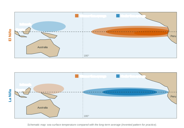
Pacific sea surface temperatures in El Niño and La Niña
4. In the El Niño map, where is the water warmer than average?
- Along the equator, east to South America
- Around Australia and the islands of Indonesia
- In the North Pacific, near the coast of Alaska
- Right along the coast of Australia and nowhere else
Show the answer
The El Niño map shows a long band of warmer-than-average water along the equator, warmest near Peru.
- Correct: Along the equator, east to South America: Right: the warm band runs along the equator to South America.
- Around Australia and the islands of Indonesia: The far western Pacific is slightly cooler than average in the El Niño map.
- In the North Pacific, near the coast of Alaska: The map shows the tropical Pacific, not the North Pacific.
- Right along the coast of Australia and nowhere else: The warm water is in the central and eastern Pacific.
5. Why is the eastern Pacific cooler than average in the La Niña map?
- Stronger trade winds push warm water west
- Weaker trade winds let the warm water spread east
- Melting ice near Peru cools the surface water there
- More sunlight reaches the western Pacific than the east
Show the answer
In La Niña the trade winds blow harder, pushing warm surface water west and pulling up more cold water off South America.
- Correct: Stronger trade winds push warm water west: Right: strong trade winds and strong upwelling cool the east.
- Weaker trade winds let the warm water spread east: Weaker trade winds and warm water moving east describe El Niño.
- Melting ice near Peru cools the surface water there: There is no ice near Peru to cool the ocean.
- More sunlight reaches the western Pacific than the east: Sunlight is similar across the tropical Pacific; winds explain the pattern.
6. Using the maps, which change would a fishing community in Peru welcome?
- A shift from El Niño to La Niña
- A shift from La Niña to El Niño
- Warmer water spreading in close to its coast
- Weaker trade winds over the equator for a year
Show the answer
La Niña cools the water off Peru with strong upwelling, which brings nutrients up and supports large fish populations.
- Correct: A shift from El Niño to La Niña: Right: La Niña brings stronger upwelling and more food for fish.
- A shift from La Niña to El Niño: Moving to El Niño would weaken upwelling and cut the catch.
- Warmer water spreading in close to its coast: Warm water near Peru signals weak upwelling and fewer fish.
- Weaker trade winds over the equator for a year: Weaker trade winds reduce upwelling.
Part 9 · Summary
Summary
Part 10 · Up next
What comes next
Part 11 · Connections