
The question
Name: ______________________ Date: ____________ A metro area map with rail lines and city limits: sprawl, transit and divided local government (7 points)
Image
Rail lines and city limits in an invented metro area
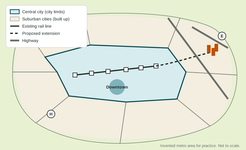
(A) Identify Identify the type of region that the whole metro area shown forms when it is defined by commuting to jobs. [1 point]
Identify means: Give the information asked for: a word or short phrase can earn the point, with no reasons needed.
(B) Describe Describe the pattern of the built-up area shown in the map compared with the city limits of the central city. [1 point]
Describe means: Give the relevant characteristics: what it is like, where and how much. A name alone earns nothing.
(C) Explain Explain why the existing rail line is of little use to most residents of suburb H. [1 point]
Explain means: Say how or why, with every link of the chain: a cause, then because or so, then its effect, tied to the place or data asked about.
(D) Explain Explain one way the split between the central city and the eight suburban cities shown can strain the central city's budget. [1 point]
Explain means: Say how or why, with every link of the chain: a cause, then because or so, then its effect, tied to the place or data asked about.
(E) Explain Explain one way the proposed extension could change land use near its new stations. [1 point]
Explain means: Say how or why, with every link of the chain: a cause, then because or so, then its effect, tied to the place or data asked about.
(F) Compare Compare transit-oriented development at the new stations with continued growth like suburb H as ways to house the metro area's growing population. [1 point]
Compare means: Give a similarity or a difference and say it about both things, not one.
(G) Explain the degree Explain the degree to which smart growth policies could reduce sprawl in the metro area shown. [1 point]
Explain the degree means: State the degree first (to a high, moderate or low degree), then explain why with evidence.